
The Wolf Creek Loop Hike Features Steep Terrain, Amazing Views, and a Rewarding Waterfall
By Amanda Lane
The Wolf Creek Loop hike is a wonderful adventure south of town on the northern side of the Bradshaw Mountain range. Trail number 384 is a moderate-to-difficult five-mile loop. A small detour from trail 384 will take you to the Wolf Creek waterfall, a seasonal 90-foot fall.
A quick note: This hike can be a little rough in the winter months. A few inches of snow in town can mean quite a bit more up in the hills. If it has snowed, wear layers you can shed as the sun and the hike warm you up. And, whether it has snowed or not, consider using trekking poles: the trail is very steep in some parts, and, if it has snowed even just a few inches, hazards are harder to see.
The trail is actually on an old road, no longer in service to vehicles over 40 inches, but open to most anyone else. I seldom see anything other than the occasional hiker, turkey or deer on any of these sections. To get there from Gurley Street downtown, head south on Senator Highway. Just after the road turns to dirt, turn right towards the Wolf Creek Campground on Forest Service Road 101, also known as the Wolf Creek Loop Road (it eventually runs into White Spar Road).
There are several spots from which to begin loop 384. I prefer to park in a dispersed camping site on road 9406L, a right turn about .5 miles down Wolf Creek Road. To be completely off the road for those who want to get by, pull into a numbered campsite.
From here I begin my adventure, heading north down road 384 (which is also trail 384). It’s well marked the entire way. The trail head is to the left off the road, about three-quarters of a mile down.
The first section of the trail includes some steep downhill sections, and provides some wonderful views of the surrounding mountains. About another mile ahead, cross Wolf Creek Road and veer slightly to the left to catch the trail again for another descent to the creek below.
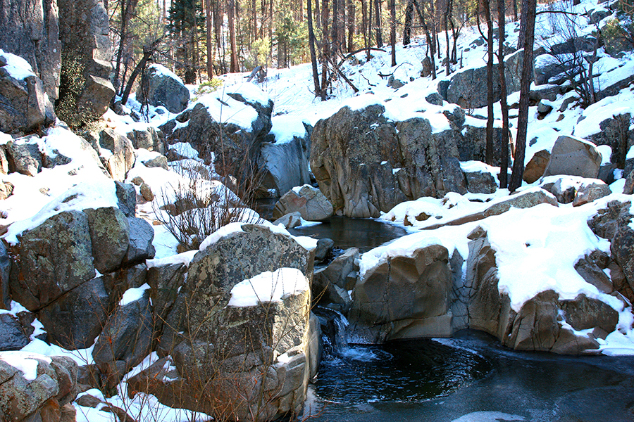
At the bottom of the hill, the trail crosses a seasonal creek that actually has running water for most of the year. After this, crossing the trail leads into a clearing. Here, you have two options: head left and follow the 384 signs up the incline, or follow the creek to the right for about a quarter-mile to the falls. If you head for the falls, you’ll encounter a large fallen tree that crosses the unmarked trail. Go under or over it, and make the scramble down to the falls (it’s not an easy one! Take your time and be cautious).
The view of the falls is worth the scramble, as long there has been enough moisture. The falls occasionally freeze in the winter, offering an even more unusual sight in this area. On my last adventure there, I found the falls had frozen over, creating a beautiful sight. This is one of my favorite places to break for lunch.
After a break, I head back up to meet the 384 trail. From here the trail winds through the hills to present some amazing views and, more often than not a few deer, and turkey as well. The trail eventually meets up with road number 74. The trail overlaps this road and follows the creek to the Payoff Springs area. A series of waterholes to your right are marked by cairns. I can remember swimming in these spots as a kid.
Just past these seasonal swimming holes you will see the sign to Payoff Springs. You are going to want to head to the left, away from Payoff Springs, to follow 384 up the hill to Wolf Creek Road. When you hit it, you will find you are directly across from the area where you parked. At an average hiking pace, and with a break for lunch, this hike can take about four hours to complete.
For more information about local hikes or supplies, visit The Hike Shack at 104 N. Montezuma Street, call 928.443.8565, or visit www.thehikeshack.com