Local lakes are now open for swimming – paving the way for new summertime adventures
By Joanna Nellans
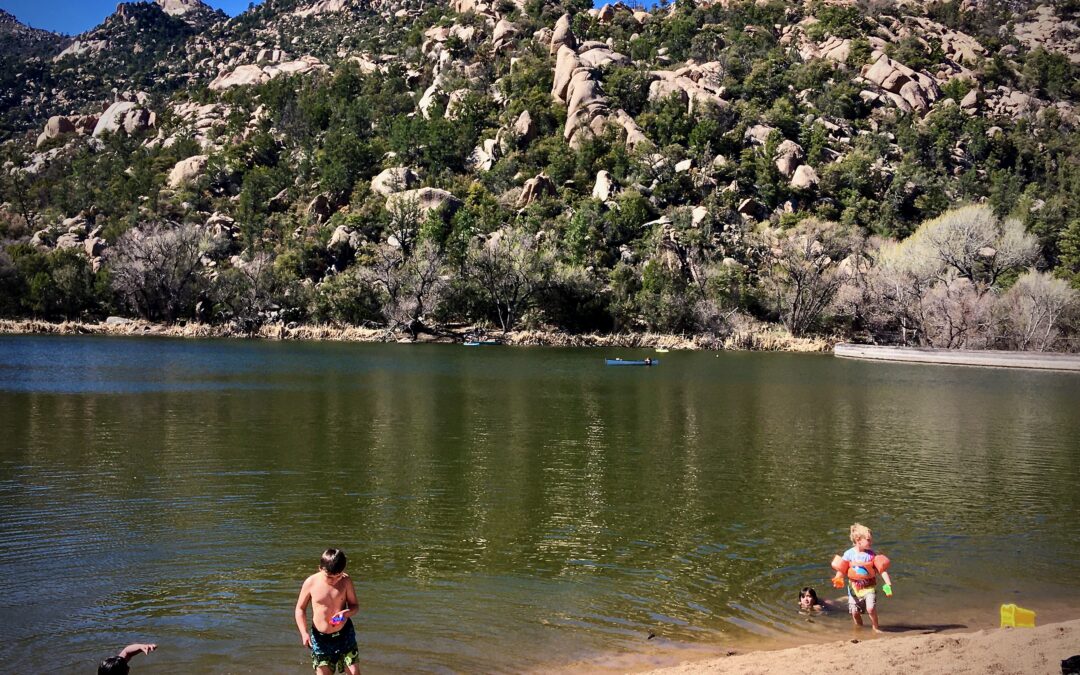
Many of us remember spending our childhood summers swimming at the local lake, and now kids in the Prescott area get to have those memories too.
For decades, all the lakes on the Prescott National Forest (PNF) were closed to swimming. Then the PNF suddenly announced on Aug. 28, 2020, that it was opening all four lakes on the forest to swimming: Lynx and Granite Basin near Prescott; Mingus on Mingus Mountain between Prescott Valley and Jerome; and Horsethief Basin near Crown King. The news release said the PNF found no current health and safety concerns but provided no further explanation.
Immediate public reactions were generally positive but mixed.
“Wow! This news is wonderful, something good about 2020,” wrote one person on the PNF Facebook announcement.
“Wow, I love these lakes, but swimming in them, there are so many bacteria and other icky things, I would be afraid,” another reader commented.
The lakes have been closed to swimming since at least 1991, but PNF officials aren’t sure if that’s the original date. They provided a 2001 order that included the lake swimming closures, but it didn’t list any reasons. The order said it was a revision of a 1991 order.
In my newspaper article back in 2007, PNF officials cited possible closure reasons as E. coli contamination and high levels of heavy metals from historical mining in the region. While they couldn’t produce any documents to back up those statements, extensive mining activity on Lynx Creek, in particular, dates back to 1863 when white settlers first discovered gold in the creek.
The lakes might have remained closed but for a recent U.S. Forest Service directive from the national office. It required forest managers to review all orders that didn’t have any ending dates, explained PNF Recreation Program Manager Julie Rowe. She said Forest Service attorneys wouldn’t let her provide a copy of the directive without a successful Freedom of Information Act request.
Rowe was tasked with reviewing the PNF order that included the lake closure and other forest restrictions. She obtained a copy of the latest Arizona Department of Environmental Quality (ADEQ) water quality reports on three of the lakes (ADEQ had not been testing Mingus) that all concluded the lakes were OK for swimming. No PNF staff had been around long enough to know for sure why the lakes were closed in the first place. So Rowe recommended opening them up, and superiors agreed.
“It was a good thing,” Rowe concluded. “We had some orders in place for decades. You want to review them to make sure they’re in the public interest.”
It’s possible that the Lynx Lake water quality had improved since it was first closed to swimming since about a two-mile stretch of Lynx Creek above the lake was closed to mining with mechanical equipment in 1971. And clean-up projects were completed earlier this century on at least two large mine sites above the lake.
Prescott Recreation Director Joe Baynes said he also will monitor the PNF changes to see if they might work on any lakes that Prescott manages, especially Goldwater where there are no water quality issues from city runoff like Willow and Watson lakes.
PNF officials will review future ADEQ reports and if the water quality is no longer OK for swimming, the lakes could close again to swimming until they’re safe again, Rowe said. In the meantime, plenty of people are enjoying the cool waters.
For more information, visit https://www.fs.usda.gov/activity/prescott/recreation/wateractivities/?recid=67155&actid=82.
If You Go...
Lynx Lake
This is by far the largest and deepest of the Prescott National Forest’s four lakes – and the most popular spot on the forest.
How’s the swimming? Numerous spots have nice solid ground under the water, including the dam area, east side and southwest side.
Size and elevation: Approximately 55 surface acres at 5,530′
Directions: From Prescott, drive east on Highway 69 to Walker Road and turn south. Drive about 2.5 miles to the north shore entrance or 2.8 miles to the south shore entrance road.
Amenities at north shore: picnic tables, seasonal boat rentals, seasonal store and restaurant. Campgrounds nearby.
Amenities at south shore: 25 picnic tables, ramadas, fire ring/grills, vault toilets, garbage service and drinking water May – October. Campgrounds nearby.
Hours: day-use only, hours vary by season.
Cost: $5 (free on Wednesdays).
Season: year-round.
Granite Basin Lake
This has the best sandy beach of the PNF’s four lakes.
How’s the swimming? Good sandy ground continues out into the lake from the beach.
Size & elevation: approx. 5 surface acres at 5,600′
Directions: From Iron Springs Road at Williamson Valley Road in Prescott, drive three miles west on Iron Springs Road to the Granite Basin Recreation Area on the right. Follow signs to lake, which has three parking areas.
Amenities: picnic tables, vault toilets, garbage service. Campground nearby.
Hours: day-use only; hours vary by season.
Cost: $5 (free on Wednesdays).
Season: year-round.
Mingus Lake
Now that the PNF has paved the first 1.4 miles of Forest Road 104, this is an easy drive for low-clearance passenger cars. The last half-mile is well-maintained gravel.
How’s the swimming? Right now the heavy silt makes the lake bottom kind of mucky.
Size & elevation: Approx. 3 surface acres at 7,573′
Directions: From Prescott at Pioneer Parkway (Highway 89A) and Willow Creek Road, drive east 19.5 miles on Highway 89A to the road’s highest point on Mingus Mountain and turn right at the Mingus Summit Rest Area/Picnic Site. Drive 2 miles up FR104 and watch for the lake and parking area on the right.
Amenities: vault toilet and covered picnic table. Campgrounds and free dispersed campsites nearby.
Hours: unlimited.
Cost: $5 (free every Wednesday).
Season: The first 1.4 miles of FR 104 is closed Nov. 1 – April 30, but you can still park at the gate and walk another half-mile to the lake.
Horsethief Basin Lake
This is by far the most remote of the four lakes on the Prescott National Forest. It’s also the only one accessed by a rough dirt road. The PNF recommends high-clearance vehicles.
How’s the swimming? We didn’t get a chance to get up there and test it, so let us know. Our Crown King friends tell us people have swam in it.
Size & elevation: Approx. 2 surface acres at 6,000′
Directions: From Crown King, take FR259A south for 0.5 miles to the junction with FR52. Take FR 52 southeast for approximately 6 miles.
Amenities: Hazlett Hollow campground and free dispersed campsites are available nearby in case you decide you don’t want to make the long drive back home (it’s about three hours from Prescott).
Hours: unlimited.
Cost: free.
Season: year-round (unless snow is blocking travel; road is not plowed).